
 On this day in history, 23rd October 1642, the first major battle of the English Civil War was fought in Warwickshire between the armies of the Earl of Essex for Parliament and the Royalist army. This battle is often seen as indecisive, but in fact the King gained a huge advantage during this battle. As Essex could not break through he had to retreat northward to the security of Warwick. This meant that the Royalists had command of the all important road to London - and control of London was the key to the war.
As the majority of the battle site now lies within Ministry of Defence land, much of the site is inaccessible including the monument to the site within Graveyard Coppice.

Photo course: The Battlefields Trust
Sources:
The Battlefields Trust http://www.battlefieldstrust.com/resource-centre/civil-war/battleview.asp?BattleFieldId=3 (accessed 23rd October 2011)
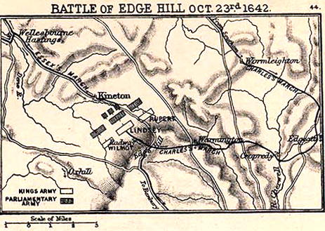
Map Of Edgehill http://www.emersonkent.com/images/battle_of_edgehill.jpg (accessed 23rd October 2011)
The map with the dispensation of troops was very helpful for visualizing the war that took place.
ReplyDeleteThanks for the post!